


KELAINAI - APAMEIA KIBOTOS


Water-sources and rivers have played a particularly important role in the life of the city of Apamea. The Marsyas and the Meander, the two principal rivers which had their sources in the city, were venerated as deities. The localisation of these sources is particularly important for the study of the topography of the city, since the ancient texts use them as geographical landmarks to locate precisely the principal centers of power (the palace of Xerxes, the palace of Cyrus the Younger, the classical agora). It is thus not surprising that the travelers and researchers of the nineteenth century, from Arundell to Ramsay, paid particular attention to this problem. The latter often proposed divergent identifications of the watercourses mentioned in the texts. These divergences demonstrate the complexity of the question, especially as the seismic activity of the region, which is relatively high, may have caused major changes in the hydrological landscape.
To answer these questions, we have undertaken a specific examination of the hydrological and hydrographical characteristics of the area. The preliminary results are very encouraging, since the most important transformations in the landscape of the region appear to date chiefly to the last three decades and are the result of human activity. The situation that existed prior to that period seems to have been very near to the ancient situation.
The source of the Marsyas
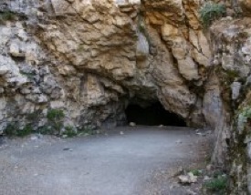
The ancient source of the Marsyas is located, according to all indications, behind the hotel Suçıkan, where is found a cave, drained today, but whose walls and ceiling were shaped by water. The flow of the source seems to have been sufficiently strong to displace large stones. The entry into the cave is located at a height of five meters and the water which remained there formed a cascade. All these characteristics correspond extremely well with the descriptions of Herodotus (7.26), Xenophon (Anab. 1.2.7-1.2.9), and Theophrastus (apud Plin. N.H. 31.19). The other caves of the area cannot be candidates for identification with the cave of Marsyas, due to their geological characteristics. In the nineteenth century, the source of this river was already no longer to be found in the cave, judging by the tales of travellers, who do not mention it; but it was not far away, on a lower level. The waterfalls which one currently sees at this place are in fact a modern installation which uses, in addition, water from another source, since pumped from a groundwater source on a lower level. The displacement of the source is undoubtedly related to a general lowering of the level of the groundwater, which has been drained. It is difficult to date this event, but it is possible that it took place during the Hellenistic period, as the cave was never mentioned again in later descriptions of the source of the Marsyas. This identification confirms the hypothesis according to which the fortified palace of Xerxes was located upon the rock of Suçıkan and the agora, mentioned by Herodotus, at its foot.
The source of the Meander
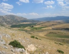
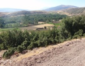
The source of the Meander can be identified, without much difficulty, with the source of Seyh-Arab-Su La source du Méandre peut être identifiée sans grande difficulté avec la source de Şeyh-Arab-Su close to the modern village of Bülüçalan. This identification was already proposed by Arundell and accepted by Ramsay, but it was not acknowledged by all scholars. Some of the travelers of the nineteenth century wrote that the river sprang from a small lake called Arapçik. This lake, however, is missing not only from certain modern descriptions but from all ancient texts. It seems, then, likely that the groundwater level could rise and sink swiftly in this region, causing the lake to appear and disappear in turn. This lake no longer exists today and trees grow on its site, but the groundwater is again close to the surface, at a depth of approximately one meter. The identification of the site of the source of the Meander makes it possible to locate, at one and the same time, the palace of Cyrus the younger and his paradeisos, described by Xenophon: it must have been located in a small valley between the village of Bülüçalan and Dikici. An analysis of the pollen from the deposits of the lake Arapçik will be able to provide us with interesting information on the history of the vegetation of this microregion, and will eventually permit us to reconstruct the physiognomy of the hunting park of Cyrus.
The lake of Aulokrene and its karstic craters
We have uncovered, in the course of our surveys, another particularity of the local hydrogeological system. A strand of the ancient tradition teaches us that the common source of the Marsyas and the Meander is located in the lake of Aulokrene, which is separated from Apamea by a mountain range (modern Akdağ). According to the ancient authors, the water of the lake disappeared beneath the mountain, then forked beneath the earth and returned to the surface in two different places to give birth to the two rivers, the Marsyas and the Meander. According to Maximus of Tyre (Diss. 2.8), who visited the city in the second half of the second century A.D., a sanctuary stood at the place where the water disappeared beneath the mountain. Sacrifice was made to Meander and Marsyas by throwing sacrifices into the water and pronouncing the name of the divinity for whom the sacrifice was intended. According to the legend, the sacrifices intended for the Meander reappeared on the other side of the mountain, in the Meander, and those consecrated to Marsyas in the Marsyas, while, finally, those consecrated to both divinities were divided in two.
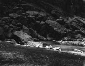
The lake of Aulokrene has always existed, but it is separated from the mountains by a dam constructed in 1980, and its level is visibly higher than it was in antiquity (as is shown by a portion of the buildings of the Roman fortress which was located on the western coast of the lake of Pınarbaşı, and which is today underwater). Today, the water has been sluiced off and directed toward Dinar by virtue of a system of artificial canals. However, it is clear that before the building of the dam, the lake water descended, in effect, beneath Akdağ through the karstic craters (always visible) and passed to the other side via karstic channels. In fact, the dam was constructed on that side of the lake in order to divide it from the mountains, which had been judged excessively permeable, and likewise to avoid the loss of water.
It has been possible to identify two groups of karstic craters through which the water of the lake descended beneath Akdağ, the first to the north, the second to the south. The first includes four craters, one of which has always been used from time to time to drain off the surplus of the lake water. These craters have been badly damaged by recent works, in contrast to the two southern craters, which are exceptionally well preserved; the principal one is located in the cave Kokarsu. In the satellite photo, one can see clearly the ancient bed of the river, which is today located beneath the lake water and which is carried out toward these craters. One can distinguish the remains of two constructions. They are scarcely visible from the surface, but a geomagnetic survey has confirmed their presence. Shards from the Roman period have been collected here, and one may conclude that we have met the sanctuary of Marsyas and Meander described by Maximus of Tyre.
Responsable des etudes hydrologiques
A. SIDORCHUK

Source of the Norgas river

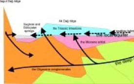
Diagram of the groundwater of the region of Dinar
(A. Sidorchuk, 2009)
Entrance of the cave behind the Suçıkan hotel
Source of Suçıkan in 1904
Valley between the villages of Bülüçalan and Dikici
The old Arapçık lake
Aulokrene lake with the bed of the submerged river

Cave of Kokarsu


updated: september 2nd, 2010