


KELAINAI - APAMEIA KIBOTOS


Les résultats apportés par les prospections géophysiques ont permis non seulement de définir, avec une méthode non invasive, la présence d'ensembles architecturaux, mais aussi de planifier et de préparer l'implantation de fouilles futures. Au cours de ces
The results obtained from geophysical surveys make it possible not only to define, with a noninvasive method, the presence of architectural complexes, but also to plan and prepare the implementation of future excavations. In the course of these surveys, we have used three different methods: geomagnetic (a fluxgate gradiometer Foerster® FEREX and a fluxgate gradiometer Bartington 602), geoelectric (a resistivity meter ADA05R) and electromagnetic (a conductivity meter Geonics® EM38-RT). The work was undertaken by two different teams: that of K. Misiewicz (Varsovie) and that of R. Chapoulie, V. Mathé and M. Druez (Bordeaux – La Rochelle). The results, integrated into GIS, were able to make more precise and complete those of the raster survey.
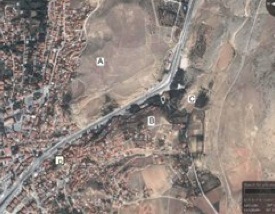
In 2008 and 2009, four regions were surveyed in and in the immediate vicinity of the city:
- Region A : atop the central hill Üçlerce which overlooks the modern city;
- Region B: atop the hill Toptepe, opposite Region A ;
- Region C: in a field (30 x 200 m) sited upon the plateau which overlooks the hotel Suçıkan, at the northern edge of the city of Dinar.
- Region D: on the site of the ancient stage of the city of Dinar.
More surveys were also carried out, at specific points, outside the city. The geoelectrical surveys involved the regions A, B and C (1.5 ha). They were completed through two campaigns of geomagnetic survey (20 ha), chiefly in region A. The regions C and D (the stage) were surveyed with the electromagnetic method.
Area A
The results of the two campaigns of geophysical survey show a high concentration of buildings and buried structures which make this area an important target for our future studies. More than fifty anomalies have been encountered there. There can be seen in many places small structures which do not follow a regular plan. However, the regular plan is typical for new foundations of the Hellenistic period in Asia Minor, which permits us to hypothesize the presence of older structures there. We have identified at least four complexes of constructions:
- the anomalies on a north-south axis, situated above the theatre, may correspond to a structure of the stoa-type, of which one of the functions seems to have been to adorn the theatre, offering a monumental access way to it.
- a linear structure which seems to gird the highest part of the hill may correspond to a defensive encircling wall of the acropolis of Apamea. This line is also shown on the ground by a clear break in the slope.
- small rectangular structures form a compact group on the summit of the hill. If the modest size of the buildings makes it possible to consider that we are dealing with homes rather than with public monuments, their topographic location, dominating the surrounding territory, encourages us to hypothesize that they must have been related to a very ancient period of occupation of the site and/or to the centre of power of the city.
- The fourth anomaly which deserves to be mentioned forms a rectilinear line which, parting from the preceding group, heads toward the south-west. Its form as well as its response to instruments, along with its uniform character, encourages us to interpret this anomaly as having probably been an axis of circulation which led from the dominant settlement (the preceding anomaly) to the exterior access ways of the protective wall.
- Finally, one should also note the presence of a complex of very large buildings inside the closed circuit, very low on the slope. The interpretation of the data is very difficult here, since a major part of the underlying ground seems to have been composed of burned masses. In the absence of modern activity in this region, we are led to think that these burnt levels correspond to an ancient event and that the buildings must have been part of a monumental complex, whose function is not possible to determine, which underwent partial destruction by fire.
Area B
The majority of the regular forms catalogued are located in the west part of the surveyed zone. The most interesting find corresponds to a complex of high resistivity with a number of linear elements. All the anomalies of this area are clearly delimited to the south and east (by the presence of a street?) Furthermore, these results are repeated at multiple levels of depth, which seems to indicate an important stack of buried remains. Similar structures were likewise found in the south-west portion of the surveyed zone. The anomalies found in the east and north-east sections are more difficult to interpret. These areas show weak responses and strong localized resistivities in the same places. It may be that this reflects an effect resulting from different levels of water transpiration, which could indicate, here as well, foundations of buildings in negative. It appears, however, that certain elements must be interpreted as the result of recent activities, without excluding the presence of archaeological remains preserved in situ.
Magnetic measurements have enabled us to obtain a similar table of electric results. One can then argue with high probability for the presence of archaeological remains near the surface and partially destroyed by modern activity. The presence of structures on deeper levels cannot be excluded, but this will need to be confirmed by a series of diagnostic soundings. The density and importance of the remains detected are clearly lower than in region A, and it does not seem that we are here in the presence of an urban center or an Achaemenid occupation, which confirms the results of the ceramological study of the material collected on the surface.
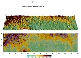
Area C
This area offers an ideal viewpoint for the control and monitoring of the important transportation route which traversed the city. One might then hypothesize the presence of a fortress, perhaps of the Achaemenid period, upon the rock. In addition, this region corresponds to one of the possible locations of the royal residence of the Achaemenid period (the palace of Xerxes). The remains expected from this type of construction could be made of stone or of raw earth. The geoelectric survey was completed here by a geomagnetic survey, as well as an electromagnetic survey. The resistivity responses are rather similar on two different levels of depth. These results seem to indicate that the succession and organization and layers of the underlying ground are less complex here than in regions A and B. Based upon the resistivity results, one can suppose that the bedrock appears only in certain places, near the visible outcroppings in the northern region of the site. Areas of high resistivity, which could reflect the presence of archaeological remains, have been especially noted in the north and west sectors. They correspond, for the most part, to the typical alignments of architectural remains, narrow structures. Most among these present regular orientations (north-south and east-west). One may also note the presence of right angles and of almost complete regular forms: squares and rectangles (underlined in blue). It is possible that these last anomalies correspond to the remains of a monumental complex. However, it cannot be excluded that they result from a natural rock substratum. Here as well, only archaeological soundings would permit us to verify these hypotheses. Electromagnetic survey shows in the same region a large structure which resembles a monumental gate. One can distinguish two constructions which could be interpreted as towers framing a passage.
Area D
An electromagnetic survey has been carried out in the area of the stage. The map thus obtained presents a band of resistance of three to four meters in width paralleling the steps in place. The intensity of the signal diminishes little by little as one moves away. It is correspondingly possible that the corresponding stone is buried more and more deeply. Also, with the knowledge of the width of the steps measured on the spot (0.6 m), it is possible to deduce the potential number of steps beneath the surface : the first band of resistance marked in violet corresponds to the lowest rank of steps level with the surface of the ground, the following two correspond to two successive levels, while the three most distant bands probably reflect the presence of three additional levels, which brings to five the total number of invisible levels which have been detected. Taking into account the height of each level and the depth of the investigation of the instrument, this figure corresponds to the greatest number of levels that it is possible to detect. It is, then, wholly conceivable that there exist more levels below these. The buried steps are added to the seven ranks actually visible upon the surface. Other steps would have to be above that which is currently the highest rank. One may then conclude the stage contained approximately twenty ranks of steps. The diminishing intensity of the signal (moving toward the green) to the south-west of the staircase can probably be explained by the disappearance of blocks, no doubt reused.
One may also note that the resistance signal forms an angle toward the north-east border of the map and then seems to continue toward the north-west (black ellipse). That may reflect the fact that this area corresponds to the extremity of the stage; the return of the steps toward the interior would then be visible within approximately ten meters. This conclusion, which would be very important for the reconstruction of the topography of the ancient city, demands verification by a physical investigation.
To the west, no line of steps facing the existing ruins was detected. If any structure existed, its remains would probably be under the road passing in front of the site. Only a band of conductivity (in red-blue) nearly ten meters in breadth (marked out by orange points) has been recorded by way of evidence. Not being parallel to the steps in place, this structure probably has no relation with the stage.
in charge of the geophysical survey
K. MISIEWICZ


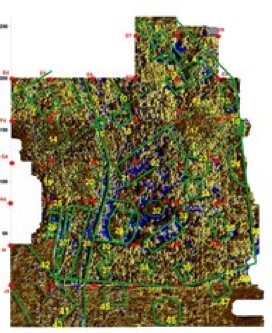
Results of the geomagnetic survey on the hill of Üçlerce (Area A)
(K. Misiewicz, 2009)
Geo-electrical survey
(K. Misiewicz & A. Dovgalev)
Geomagnetic survey
(R. Chapoulie)

Electromagnetic survey
(V. Mathé)
Results of the geo-electric survey on the hill of Toptepe (Area B)
(K. Misiewicz, 2008)
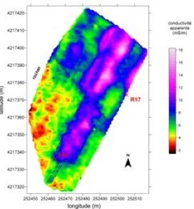
Results of the geo-electric survey in Area C
(K. Misiewicz, 2008)
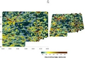
Results of the electromagnetic survey in southwestern part of area C
(R. Chapoulie, V. Mathé, M. Druez, 2008)

Results of the electromagnetic survey on the stadium
(Area D)
(R. Chapoulie, V. Mathé, M. Druez, 2008)
Areas of the geophysical surveys


updated: september 2nd, 2010