


in charge of the survey in the town of dinar
F. MAFFRE
Objectives
As our project is, above all, to study, on the one hand, the progress of urbanisation in the region, based upon the example of Kelainai-Apamea Kibôtos, and, on the other hand, to map the ancient cartography on the present-day land register of the village, a series of surveys was undertaken in July 2008, to end in July 2010. Two objectives have thus been set:
1- To evaluate and inventory the ancient material which can be identified in the streets, walls, gardens, and, so far as possible, houses of the modern city.
2- To identify the placing of ancient buildings, with the ultimate goal of laying out a first plan not only of site occupations for the periods that interest the Kelainai project, but also of areas that could be auspicious for future archaeological excavations. Moreover, with a team of architects, we are working upon the identification of artifacts in order to attribute them to one structure or another and to determine their geographical provenance.
Problematic
Despite the ancient sources and recent commentaries concerning the cities of Kelainai-Apamea Kibôtos and the area occupied by the Achaemenid palaces, no certainty exists as to the precise identification of the sites, to say nothing of their localisation. Certain structures in situ permit us to reconstruct the ancient civic layout: the theatre installed on one of the slops of the hill of Üçlerce, which served as an acropolis, a series of steps confirming the presence of a stadium, as well as the remains of an exedra. 100 metres to the north-east of this structure, there exists also a cave of cultic significance in which were discovered, in 1970, two statues of deities. Two arches of a fountain likewise still exist within the city. Finally, the necropoleis testify to the existence of a space reserved for burials in the immediate vicinity of the city. With the exception of these few urban elements, everything remains to be discovered and placed upon a plan. Epigraphical evidence also supplies copious information concerning the existence of this or that structure and the characteristic sectors of a Greek city. Also, many inscriptions make reference to the titles of agoranomos and gymnasiarch, in the agora (IGR IV, 790) as well as Skutikè plateia (the main Street of the Shoemakers) and Thermaia Plateia, which probably takes its name from the spring Therma (IGR IV, 790, 789, 788 et 791). Reading these pieces of evidence, it then appeared to be of interest to undertake a survey extended to the whole of the territory of Dinar, in order to enrich an already important dossier of epigraphical and architectural material.
Methods
The mayor of Dinar, Mr. Saffet Acar, has placed at our disposal all the resources of the technical and cartographic services of his city, and the head of construction services, Mr. Mestan Gürgül, has provided us with a general plan. The police services have likewise placed at our disposal sketches of each quarter (mahalle).
This division, like every division, is arbitrary, but the defining of certain quarters may be very ancient and related to historical causes. It also has the advantage of being based upon clearly defined and current boundaries. We have equally benefited from access to the private collection of old photographs and postcards belonging to Mr. Mehmet Özalp, in charge of the cultural service of the town hall of Dinar, and to Mr. Ayhan Kalkan, which has permitted us to measure the changes which have taken place in the city of Dinar since the beginning of the twentieth century. Finally, the assistance of Mr. Mehmet Özalp has been invaluable, in that he has pointed out to us the location of ancient blocks and inscriptions, and has informed us about the exact provenance of certain blocks which are today exposed in the park of the hotel, near the slaughterhouses, the spring of Incirli and the municipal workshops.
We have gotten our bearings through a satellite image and plan of the municipality, which has permitted us to visit the best part of the streets, lanes, culs-de-sac, gardens, fields, and riverbanks. Each find was the object:
-
-of an information card in a database permitting us to identify it and localise it in the terrain;
-
-of a GPS positioning and a localisation in the land register, when this was possible;
-
-of a photograph (one or more, according to the interest of the artifact);
-
-of an identification, when that was possible, and a description;
-
-for the most characteristic archaeological objects, a series of measurements.

KELAINAI - APAMEIA KIBOTOS


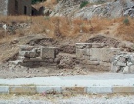
Stone exedra at the foot of the hill of Üçlerce
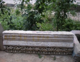
Decorated architrave dating to the 2nd-3rd centuries A.D.
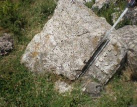
Fragment of a Doric moulding with its guttae.
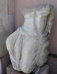
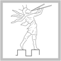
Statue discovered in the cultic cave below the Suçıkan rock.


updated: september 2nd, 2010