


KELAINAI - APAMEIA KIBOTOS


The first two campaigns (2008-2009) were dedicated in large part to surveys which were carried out in the town of Dinar as well as in its countryside. The results of these surveys have been regularly integrated into the GIS. The result of these surveys has been the discovery of a number of important habitation sites and funerary monuments in the region of Dinar.
Necropoleis
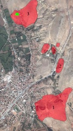
One of the goals of the surveys undertaken around the city of Dinar (2008-2009) was the establishment of a funerary topography of Kelainai/Apamea. Besides its intrinsic interest, regarding the extent, chronology and typology of the tombs, this study permits us to establish the limits of the ancient city. Many important necropoleis which surround the modern city have been identified in the course of these surveys. The total surface area of the identified necropoleis appears to cover about one hundred fifty hectares.
The necropoleis display a wide variety of types of tombs. They include above all rock tombs, with or without a dromos, of which the ceilings display two different configurations: horizontal and double-sloped; some burials which are small tumuli (often decorated with phallic funerary steles); some burials in the form of a chest, built from limestone flagstones; some monumental sarcophagi in stone, and others, simpler, in terra cotta.
The necropolis (1) situated to the south of Apamea, upon the hill of Karabayıl, is the one which we have been able to study in a more complete fashion than any of the others. The necropolis occupies the whole of the hill, as well as adjoining spaces to the east (for a total surface area of approximately 1500 x 1000 m). The degree of preservation of the tombs is very poor, principally because of looting, but also because of the presence of a modern quarry in the western part of the area. A great number of rock tombs have been identified on the west face of the hill, while its summit displays a series of small tumuli. In addition to the famous sarcophagus of Dinar (Topbaş 1987, 361-374), which was found in the same area, one of the tombs found here deserves special attention. It is a tomb with two chambers, partially dug in the rock but certain of whose parts (the wall and the ceiling) were constructed by hand. The character of the tomb fittings and the method of construction permit us to assign a date within the Hellenistic period. This chronology also corresponds to the ceramic shards collected in the embankments of clandestine excavations around one of the tumuli on the top of the hill. It seems, in consequence, that at least one part of this necropolis dates to this period, and that two types of tombs (rock tombs and tumuli) were conceived of concomitantly.
Another necropolis (2) has been identified to the north of the hill of Karabayıl. It occupies the greater part of the hill Kapıkaya et the southern part of the slope of the hill Kanlıkaya. The districts of the modern city which lie at the southern foot of the hill Kapıkaya appear to occupy part of this necropolis, since a phallic funerary stele, as well as an ostotheke, have been found there. The same necropolis no doubt continued toward the east, to the other side of the modern Dinar-Afyon road, and it is very likely that the necropolis identified to the northeast of the hotel Suçikan formed part of it. The types of tombs are the same as in the southern necropolis, that is to say chiefly rock tombs and tumuli.
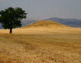
Another large necropolis (3) is located at a distance of 1.2 to 1.9 km to the northwest of the hill of Uçlerce, upon the hill of Tavşan. By our estimate, its surface area seems to be roughly 1000 x 850 m. The state of preservation of this necropolis is by far the best, despite the fact that one finds here too traces of recent pillaging. In the eastern part of the necropolis, one may note the presence of a large tumulus, of which the mound is preserved to a height of 8 to 10 m. Located upon the summit of a natural hill, its diameter measures between 60 and 65 m (its eastern part is badly damaged thanks to a large trench resulting from plundering). This tumulus is the largest funerary monument of the necropoleis of Kelainai/Apamea. Its dimensions and its topographical location recall very clearly the famous tumulus of Tatarlı, situated 40 km to the east of Dinar.
Another necropolis (4) has been identified between the villages Bülüçalan and Dikici to the south-east of Apamea. The exact dimensions of this necropolis cannot be clearly established, but one may note, near the Dikici/Bülüçalan road, a group of pillaged tombs. It is very likely that the funerary constructions found at the southern edge of the village of Dikici (roughly 1.5 km to the south of this area) belonged to the same necropolis. A tumulus, with a preserved height of approximately 5 m, was recently pillaged. According to information given by the inhabitants of the village, it contained an extremely rich grave. Some remains of many other tombs, both rock tombs and constructed, have been found around this tumulus. This vast necropolis seems to be too far from Dinar to be easily set in relation with Kelainai/Apamea. It might therefore be the case that it is related to a fortified building discovered close by.
A final necropolis (5) was probably located on the south-west slope of the hill Çeleka, to the south of Dinar; its surface area is roughly 4.5 ha. In certain spots, the rock appears to have been cut away in a fashion that suggests access to subterranean rock tomb funerary chambers. The necropolis appears to have been spared from plundering, at least that of modern times.
Tumuli
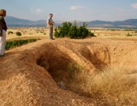
The presence of tumuli is one of the characteristic traits of the landscape of the Kelainai/Apamea region. Along with small groups of tumuli which contain between 2 and 6 monuments, one finds some large isolated mounds. Excluding those which are located in the necropoleis of the city, we have identified 12 tumuli in the plain to the west of Dinar, notably a group of 6 tumuli between the villages of Tekin and Pınarlı. These last are of heights varying between 2 and 10 m. Nearly all have been pillaged, certain ones very recently, which may be indirect testimony to their wealth. Regrettably, no archaeological material has yet been able to be recovered around these monuments; it is, therefore, impossible to date them. It will consequently be necessary for us to proceed with a series of cleanings and excavations if we wish to learn more.
Tells (höyüks)
The region of Apamea was no doubt populated in a rather dense fashion in the Bronze Age, if not before then. This point is attested not only by the pottery found on the hill Üçlerce, but also by the presence of structures of the type höyük (tell) in the region. We have identified and surveyed nine structures of this type, of which one is located in the city of Dinar (the others are: Bekirli 1, Pınar Höyük, Kabaklı, Yeşilhüyük, Çandır I and II, Ak Höyük, Pınarbaşı Höyük). These tells were already mentioned by J. Mellaart (1954), but he gave no description or exact location for them. They have nevertheless being registered in the database TAY (Türkiye Arkeolojik Yerleşmeleri – The Archaeological Settlements of Turkey: http://www.tayproject.org), whose reliability is relative (the presence of remains of the Greco-Roman period that we have found on the summit of this tell, for example, is ignored). The pottery collected at these sites dates chiefly to the ancient Bronze Age, sometimes to the Neolithic and Chalcolithic periods; the tells Bekirli, Çandır I and II, Dinar Höyük, and Ak Höyük were reoccupied in the Roman period; that of Dinar Höyük had already been in the Achaemenid period.
Fortified establishment of Dikici
A fortified establishment has been identified 6 km from Apamea to the south-east, at an equal distance (roughly 1100 m) from the villages of Bülüçalan and Dikici. The establishment is situated upon a plateau which dominates the valley. The remains of a fortification wall surrounding the site (roughly 2 ha) are clearly visible on the surface, especially in the southern portion. The north portion has been plowed, which explains the absence of visible remains of structures on the surface, but a geomagnetic survey confirmed their presence underground. One can also find, in the northern part of the site, the remains of two towers aligned on an east-west axis, which probably guarded a gate. Two springs, situated to the north and south of the site, which must have been exploited in antiquity, are still in use. It seems, judging from the collected pottery, that this establishment dates to the Hellenistic and Roman periods. A large necropolis discovered near Dikici appears to belong to this site. Its dimensions testify once again to the significance of the occupation. We may be dealing with one of the villages belonging to the city of Apamea which are mentioned in the literary sources, notably in Dio Chrysostom (35.14).
Secondary establishments
Two fortified establishments have been identified near the village of Dikici, on two hills close together but separated by the Meander. Large worked blocks of limestone, and many fragments of pottery and tiles from the Roman and late Roman periods have been found at these sites. The function of these establishments is not clear.
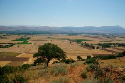
Traces of occupation have been identified in the valley between Yelliboyan Tepe and Piretekkesi Tepe, thanks to satellite photos. This small valley, approximately 1600 m long, is located at an altitude of 1100-1130 m. It is bordered by scarped slopes which make access difficult; this no doubt explains the fine state of preservation of the ancient remains in the valley. One may find here the remains of a grid division of land, again clearly visible on the surface, and of a communication route. We have been able to identify remains belonging to two establishments of small dimensions which may have been villages or farms. The plans of the buildings, constructed in unworked stone, are clearly visible on the surface. Unfortunately, the small amount of pottery collected in the course of the survey does not present sufficiently distinctive characteristics to date the establishments. Two villages have been identified to the west of Dinar. The first is located 700 m to the west of the modern village of Çakıcı and covers a surface area of 6 ha, the second is located 3 km to the north-northwest of the modern village of Oğullar. The remains of the houses are clearly visible on the surface; the collected poetry dates to the Byzantine period.
in charge of the survey in the region
A. IVANTCHIK

Region of Kelainai - Apamea
Necropoleis around Apamea
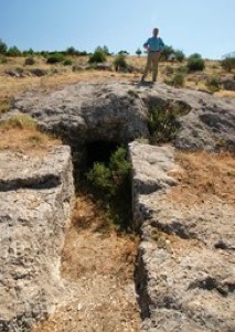
Funerary chamber with dromos
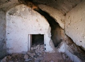
Hellenistic tomb
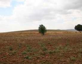
Tumulus between the villages of Tekin and Pınarlı
Destroyed Tumulus
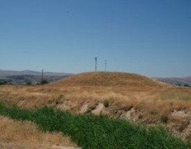
Bekirli Höyük
Dinar Höyük
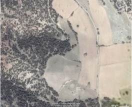
Site of Dikici - satellite photo
Site of Dikici
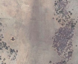
Valley between Yelliboyan Tepe and Piretekkesi Tepe -
satellite photo

Survey in the region of Dinar

updated: september 2nd, 2010