


KELAINAI - APAMEIA KIBOTOS


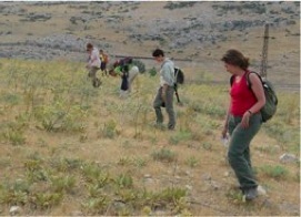
The surface of the hill of Üçlerce (the central hill of Apamea, ca. 36 ha) is almost entirely free of modern buildings, and presents ideal conditions for a systematic survey. The same is true for the northern edge of the hill Toptepe, the rock Suçıkan and the nearby plateau of roughly 2.5 ha (the probable locality of the palace of Xerxes), which overlooks what has been identified as the source of the Marsyas. We decided to proceed with a raster survey on these hills and the adjoining slopes. The topographic grid necessary for the survey was put in place prior to our first campaign by the local geodesic bureau of Sami Dayan. The areas of study were divided into squares of 40 m on a side, with the aid of a total station, and each square was the object o a study by a group of five people, progressing in strips of 5-10 m. The squares were mapped onto the terrain with the aid of wooden pieces, in order not to interfere with the geophysical surveys, which made use of the same grid.
The coordinates of each square were entered into the GIS. Our goal is to obtain, ultimately, a qualitative and quantitative map of the location of ancient material and to determine the areas of concentrations of habitats, as well as their evolution in the course of time.
The highest concentration of pottery is attested on the hill of Üçlerce, where, no doubt, the “high city” of Apamea was located. Roman and, to a lesser degree, Hellenistic pottery is dominant, but the material proves that the hill was likewise inhabited in the Archaic and Classical periods, as well as earlier period (the Bronze and Iron ages). The concentration of pottery from the Iron Age (notably the Achaemenid period) is particularly marked on the higher part of the hill. This makes probable the hypothesis according to which not only the acropolis of Apamea, but also that of Kelainai, was located on this hill.
The concentration of pottery on the second hill, Toptepe, is clearly less great, and Iron Age material is virtually absent. The area of the rock of Suçıkan, on the other hand, has produced pottery of different periods, notably of the Archaic and Classical periods. This appears to confirm the hypothesis of the presence here of fortifications from the Achaemenid period. In addition, there have been found in the same area bronze arrowheads and stone bullets that have been identified as projectiles of war machines. One may suppose that the presence of these bullets and arrowheads, some of the latter of which are bent, reveals the traces of an assault on the fortress that was located on the rock. Identifying the enemy who attacked the city is difficult, but the presence of “late” types among the arrowheads permits us to exclude the Cimmerians (first half of the 7th century B.C.) and the Persians (middle of the 6th century B.C.) We may, on the other hand, be dealing with the siege of Kelainai by the army of Alexander the Great.
In charge of the survey on the hill
L. SEMENTCHENKO - A. Nunn (2009), I. Dinkel (2008)
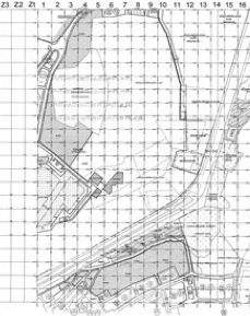

The topographic grid
Raster Survey


updated: september 2nd, 2010