


KELAINAI - APAMEIA KIBOTOS


We chose from the beginning to use GIS as a primary method of storage, presentation and analysis of data obtained during field survey. The first stage of labor in the preparation of prospecting in the field, was the creation of the basis for future GIS. We used this high-resolution satellite photos taken in October 2006 by the QuickBird camera. These were complemented by other satellite photos we can find freely available on the website maps.google.com. The total consideration covers 200 km2. These images were then processed and converted to WGS-84 projection to allow their joint analysis by the software ArcGIS. This treatment has allowed to use GPS receivers to move during surveys on the ground, especially when searching structures identified from satellite photographs.
In addition to satellite images, GIS base map also includes a digital model of the Earth's surface in three dimensions. This model, based on detection by radar, was loaded from the server of NASA (SRTM - Shuttle Radar Topographic Mission). It has created a TIN terrain model to study the territory and to assign three-dimensional coordinates archaeological artifacts.
The third element of the base GIS is a series of topographic maps at scale 1 / 25 000 and 1 / 100 000. These maps have been processed so that they are consistent with the QuickBird satellite photos. We also took into account the plans published in the nineteenth century. We are aware of the low accuracy of the latter, they are nonetheless interesting for the names and the remains (now extinct) they refer to, as well as knowledge of the river system has changed from the nineteenth century. These maps have been corrected from the most recent data before being integrated with the rest of the equipment in the GIS.
After creating the GIS, the second stage of labor was the deciphering of satellite photos and topographical maps together into a single system. In this analysis, several archaeological structures have been identified: institutions, cemeteries, buildings, roads etc.. The presence of these elements has been verified by a field investigation and, if confirmed, documented in detail (description, photograph, address, etc..). They formed the first group of data entered in GIS.
The third stage was an intensive survey on the ground. This systematic survey has revealed many new elements that have been documented in detail before joining the GIS database (the value of their coordinates have been calculated by GPS, they have a printed 1 to 4 m) . The heights have been accurately determined using the TIN model. During the first two years of surveys about 300 objects and structures (identified, geo-referenced, documented) were recorded in the GIS.
in charge of the gis
A. BELINSKIY- A. DOVGALEV

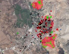
Sample of the GIS map

Tridimensional model of the region of Apamea, including informations from the GIS and the limit of the necropoleis areas.


updated: september 2nd, 2010